
Temperatures in the UK are set to be higher than those in Athens, according to the Met Office, as the cold snap of January comes to an end.
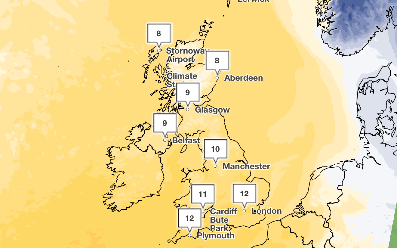
Across the UK, temperatures have reached double digits with a peak of 12C in Plymouth and in London at around 3pm on Monday, according to the national forecaster.
The coldest temperature is 7C in Aberdeen, and the weather varies between 8 and 9C in other parts of the country.
Meanwhile in Athens, Greece, the temperature is 6C on Monday, with winds reaching 28mph, according to the Met Office. Similarly, temperatures in the UK are warmer than Istanbul in Turkey, which is currently at 4C and London is hotter than Madrid, Spain, which is averaging around 9C.
This comes after extreme snow and winds last week during Storm Goretti, which saw the closures of hundreds of schools, power outages and dozens of flight cancellations due to hurricane-force winds.
Last week saw at least 69 flights from Heathrow airport cancelled, causing disruption for 9,000 passengers. There were also 37,000 properties without power in the South West at around 8pm on Friday, according to the National Grid.
A rare red weather warning was issued for “dangerous and stormy” winds in the South West, where a man died after a tree fell on a caravan due to the strong winds of almost 100mph.
The Met Office has reported that mild air has moved in from the West, bringing rain and blustery conditions, following a spell of heavy snow on Saturday night and Sunday morning in some regions of Scotland, where snowfall has now turned to rain.
The rain is expected to be heavy and persistent in northern, western and south-west Scotland, which is likely to bring an increased risk of flooding in addition to melting snow.
Met Office chief meteorologist Matthew Lehnert said: “We’ll see a transition in our weather across the UK through Sunday, with mild Atlantic air moving in from the west. Temperatures will rise and we’ll see rain rather than snow accompanying some strong gusty winds in the north. Warnings have been issued for heavy and persistent rain, as well as these strong winds overnight in western and northern Scotland.
“While the wintry weather may have come to an end, the significant snow accumulations in parts of Scotland mixed with heavy rainfall and an increase in temperatures bring a risk of flooding in some areas as the snow melts. Keep up to date with the flood warnings issued by SEPA and check your flood risk.”
Flooding has brought disruption to some parts of Scotland, with flood warnings in place in several areas as a result of the heavy rain and melting snow.
There are 19 Scottish Environment Protection Agency (Sepa) flood warnings, and 12 flood alerts in place around the country as of Monday morning.
The Met Office yellow warning of rain for much of north-west Scotland is expected to last until 10am on Monday, while a warning of wind expired at 8am. Another yellow weather warning for ice is in place from 7pm on Monday until 10am on Tuesday.
Authorities have warned people to be “vigilant” of the weather conditions.
David Morgan, Sepa’s flood duty manager, said: “Continuing heavy rain, combined with melting snow, increases the risk of flooding. Flood risk is greatest in Dumfries and Galloway and the west and north of Scotland.
“Possible impacts could include flooding affecting parts of communities, low-lying land, transport infrastructure and individual properties. Driving conditions will be very difficult at times.”
Scottish justice secretary Angela Constance said: “As wintry conditions ease across the country, we are urging the public to remain vigilant.
“Rising temperatures and heavy rainfall, combined with melting snow, bring a significant risk of flooding in several areas.
“This could affect properties and transport routes, with difficult driving conditions expected in many parts of the country at the start of the working week.”
Met Office five-day weather forecast
Monday
It is expected to be a wet and windy morning across northern Scotland. Forecasters predict it to be drier elsewhere, with a mixture of sunshine and showers. For many it will be cloudy, with longer spells of rain developing. There will be a few brighter breaks possible at times and the weather will be mild but rather windy.
Monday evening
The conditions are likely to remain unsettled, with further outbreaks of rain, which could be heavy at times. There will be some clearer spells, mainly for north-east Scotland, where patchy frost is possible.
Tuesday:
Tuesday will see sunshine and blustery showers across Scotland and Northern Ireland. Forecasters predict it to be cloudy for England and Wales, with further spells of rain, which will be heavy in places. It will feel a little colder.
Wednesday to Friday:
After a frosty start, Wednesday should be dry and bright but chilly. Wet and windy weather pushing north-eastwards through Thursday, followed by blustery showers on Friday. It is likely to feel milder in the south of the UK.
#Britain #warmer #Athens #today #Met #Office #declares #cold #snap

